Number 38 of 282 by height · Cairngorms and Monadhliath
Aonach Beag
3,661 ft (1,116 m)
Facts
- Grid reference
- NN 457 741
- Latitude, longitude
- 56.83351, -4.52919
- Area
- Cairngorms and Monadhliath
The walk up
No route line yet: the mapped paths near the summit do not join up with a car park. See Getting there below for the nearest place to park.
Summit conditions
From Sunday 1 November, 21:21. Not live.
- Weather
- Clear sky
- Temperature
- 30°F (−1°C)
- Wind
- 2 mph (4 km/h) from the northwest
- Cloud cover
- 6%
- Rain or snow, next hour
- None
- Freezing level, rough estimate
- 3,054 ft (931 m), below the summit
- Sunrise, sunset
- 07:27, 16:36
Getting there
By car
Car park with no name on the map. Parking charge not known. The nearest public car park to the summit, 5.7 mi (9.1 km) away in a straight line. Not necessarily the usual start.
Driving directions to the Aonach Beag car park56.90367,-4.60663
By train
Nearest station: Tulloch, 3.8 mi (6.1 km) from the car park.
By bus
Nearest bus stop on the map: Moy Lodge - Eastbound, 1.8 mi (2.9 km) from the car park. Check the times first: many Highland buses run only a few times a day.
Public transport directionsBus and train times on Traveline Scotland
About Aonach Beag
- Means
- Little ridge
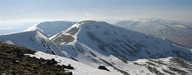
Aonach Beag lies in remote country between Loch Ericht and Loch Laggan, about 2.5 miles north-west of Ben Alder, in a line of hills running between Loch Ossian and Loch Pattack. Three ridges meet at its summit. Geal-Charn, 0.8 miles to the east, is its nearest higher neighbour, and it rises 325 ft (99 m) above the col that links it to higher ground. It is not to be confused with the better-known Aonach Beag near Ben Nevis, about 19 miles to the west.
To the west is Beinn Eibhinn, 0.7 miles away, which spreads over more ground but is slightly lower. Lochan a' Charra Mhoir lies between the two at the head of Coire a' Charra Mhoir.
The hill sits within the Ben Alder and Aonach Beag Special Area of Conservation, noted for its acidic scree and alpine grasslands, and its long snow cover makes it exceptional for mosses and similar plants. A cairn marks the summit.
Through the year
Hours of daylight on Aonach Beag in the middle of each month. The shorter the day, the earlier you need to start.
Stag stalking season, 1 July to 20 October. On many estates, walkers are asked to keep to set routes on stalking days: check the Scottish Outdoor Access Code site's Heading for the Scottish Hills service before you go.
Nearest Munros
| Munro | Height | Straight-line distance |
|---|---|---|
| Beinn Eibhinn | 3,620 ft (1,103 m) | 0.7 mi (1.2 km) |
| Geal-Charn | 3,714 ft (1,132 m) | 0.8 mi (1.3 km) |
| Beinn a' Chlachair | 3,566 ft (1,087 m) | 2.6 mi (4.2 km) |
Common questions about Aonach Beag
- How high is Aonach Beag?
- Aonach Beag is 3,661 ft (1,116 m), number 38 of the 282 Munros by height, in the Cairngorms and Monadhliath.
- How long does it take to climb Aonach Beag?
- We do not have a mapped route up Aonach Beag yet, because the paths near the summit are not joined up on the map. Plan it with a proper map and allow a long day.
- Where do you park for Aonach Beag?
- The nearest public car park to the summit is a car park with no name on the map.
- Can you climb Aonach Beag without a car?
- The nearest railway station is Tulloch, 3.8 mi (6.1 km) from the start, and the nearest bus stop on the map is Moy Lodge - Eastbound, 1.8 mi (2.9 km) from the start. Highland trains and buses are few, so check times on Traveline Scotland before you go.
- What does Aonach Beag mean?
- It is usually translated as "little ridge".
- When is the best time to climb Aonach Beag?
- Daylight runs from about 18 hours in mid June to 7 hours in mid December, so summer gives the most time. From 1 July to 20 October it is the stag stalking season, when some estates ask walkers to keep to set routes. In winter, snow and ice turn most Munros into mountaineering terrain.
A guide only. Mountain conditions change fast: carry a map and compass and know how to use them, and read the mountain forecast for the Cairngorms and Monadhliath before you go.
Questions
Where can I get a proper mountain forecast?
Read the Mountain Weather Information Service forecast for the Cairngorms and Monadhliath, written by forecasters for walkers and climbers. In winter, also read the Scottish Avalanche Information Service report for the area.
Where does the summit weather come from?
From MET Norway's forecast model, fetched for every Munro once an hour at the summit's own height. It is computer output for one point, not a forecast written for mountains, so treat it as a guide. The past hours are what the forecast said at the time. Wind chill, the freezing level and sunrise and sunset are worked out by this site from those figures; the freezing level assumes temperature drops steadily with height, so it can be well out when cold air sits in the glens.
Where do the car parks and bus stops come from?
From OpenStreetMap. Distances are straight lines, not the way you would walk or drive. A bus stop on the map says nothing about how often a bus calls: many Highland buses run a few times a day, some only on school days or by booking, so check Traveline Scotland first. The map cannot tell whether a car park is on a public road, so a remote one may only be reachable on foot or by train.
Where do the Gaelic names and stories come from?
From the hill's article on English Wikipedia and its Wikidata entry, put into a few words of our own. Meanings and pronunciations are only given where the article states them; many Gaelic hill names are old and their meaning is uncertain. Read the full article.
Where do the height and grid reference come from?
From the Database of British and Irish Hills, the surveyed list most baggers use. Aonach Beag is hill 347 there.
Sources: Database of British and Irish Hills (CC BY 4.0), OpenStreetMap (ODbL), MET Norway (CC BY 4.0), Wikipedia (CC BY-SA 4.0) and Wikidata, Copernicus elevation data, Sentinel-2 cloudless imagery by EOX. All credits and licences.